
Perspectives


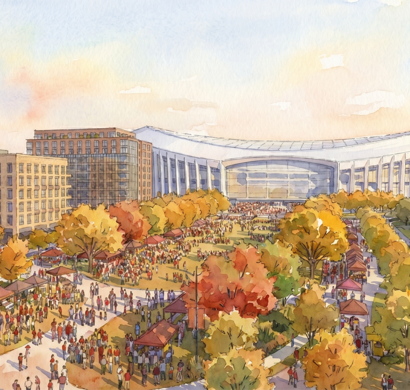
A new football stadium is coming to DC, returning the Washington Commanders to the site where they played until 1996 and catalyzing the redevelopment of the surrounding 180-acre RFK campus into a year-round destination. The site, which once revolved around RFK Stadium, one of the country’s first true multi-purpose stadiums, has sat largely vacant and underutilized since 2019.
The transformative $3.7 billion redevelopment will be anchored by a new 65,000-seat, domed stadium. Once completed, the stadium will be home to the Washington Commanders and is anticipated to host approximately 200 additional events annually, including concerts, major sporting events, and other large-scale entertainment programming. The District also plans to pursue bids for major global sports and entertainment events.
Just as important as the new world-class stadium, the RFK campus redevelopment will transform the 180-acre site into a vibrant, transit-oriented neighborhood with 5,000 to 6,500 new housing units, offices, retail, and athletic and recreational facilities. The once in a generation development will bring much-needed housing supply to the region, with 30% of new units designated as affordable, creating new opportunities for District residents across income levels.
Realizing this vision will require, among many factors, significant investments in transportation and mobility. To adequately serve large sporting events, concerts, and the broader year-round community envisioned for the site, significant transit and mobility improvements will be needed. This deep dive examines the site’s existing mobility conditions, how travel demand is expected to evolve as redevelopment progresses, and the transportation investments currently under consideration.
Existing Mobility Conditions: Strong Regional Access, but a Disconnected Campus
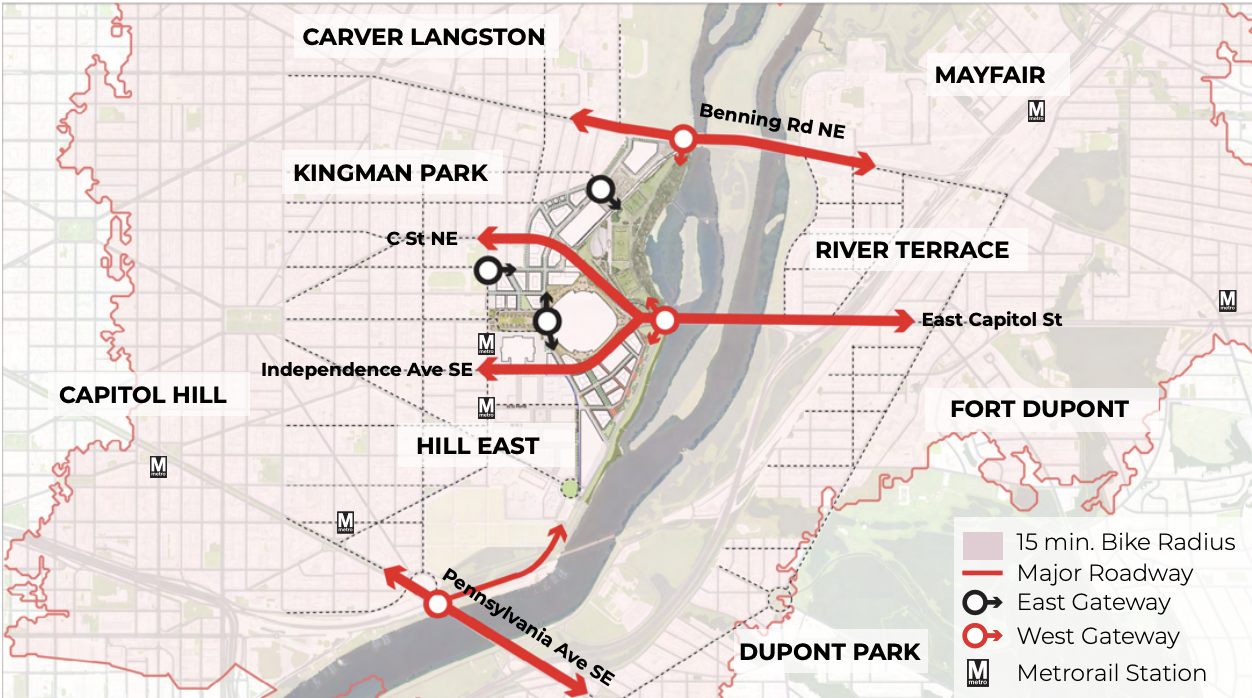
Context plan for RFK Campus and connections to surrounding areas. Source: Robert F. Kenedy Campus Master Plan: Development Framework and Design Guidelines Public Comment Draft – June 30, 2026 The RFK Campus benefits from a highly connected location at the intersection of Capitol Hill, Kingman Park, Hill East, and the Anacostia River. East Capitol Street provides a direct connection between the site and the monumental core, while the Whitney Young Memorial Bridge links the campus to communities east of the river. Benning Road and Pennsylvania Avenue provide additional regional connections, and nearby access to I-295 supports regional travel from surrounding jurisdictions. However, the campus’s internal road network and extensive surface parking lots reflect its historic use as a single-purpose event destination, creating large gaps between surrounding neighborhoods, recreational areas, and the waterfront. Transit is one of the site’s greatest existing strengths. The Stadium-Armory Metro station, located 0.4 miles (9-minute walk) west of the campus, is served by the Blue, Orange, and Silver Lines, providing direct connections to downtown Washington, Northern Virginia, and Prince George’s County. The area is also served by Metrobus routes along East Capitol Street, Benning Road, and surrounding neighborhood corridors. However, WMATA has found that the station was designed to serve a smaller stadium with substantially more on-site parking than what is currently proposed. Its existing vertical circulation and mezzanine space, particularly at its northern entrance, constrain its ability to accommodate the passenger volumes associated with stadium-scale events. Pedestrian and bicycle access is more uneven. To the west, the street grids of Capitol Hill and Kingman Park provide frequent connections to the campus, and existing pedestrian routes extend into the site. However, large parking areas, wide roadways, limited crossings, and the site’s long-standing separation from surrounding neighborhoods have resulted in many of these connections feeling indirect or uncomfortable. Access to the Anacostia River is similarly fragmented, while the three principal river crossings at Pennsylvania Avenue, East Capitol Street, and Benning Road remain primarily designed to move vehicle traffic rather than support safe and comfortable walking and bicycling. Transportation demand for a new stadium For a destination expected to host large-scale events while supporting a vibrant, year-round neighborhood, providing multiple transportation options is essential. Without adequate multimodal transportation capacity, constrained ingress and egress could result in traffic gridlock, overcrowded transit stations and service delays, and significant congestion on surrounding neighborhood streets. Transit
|
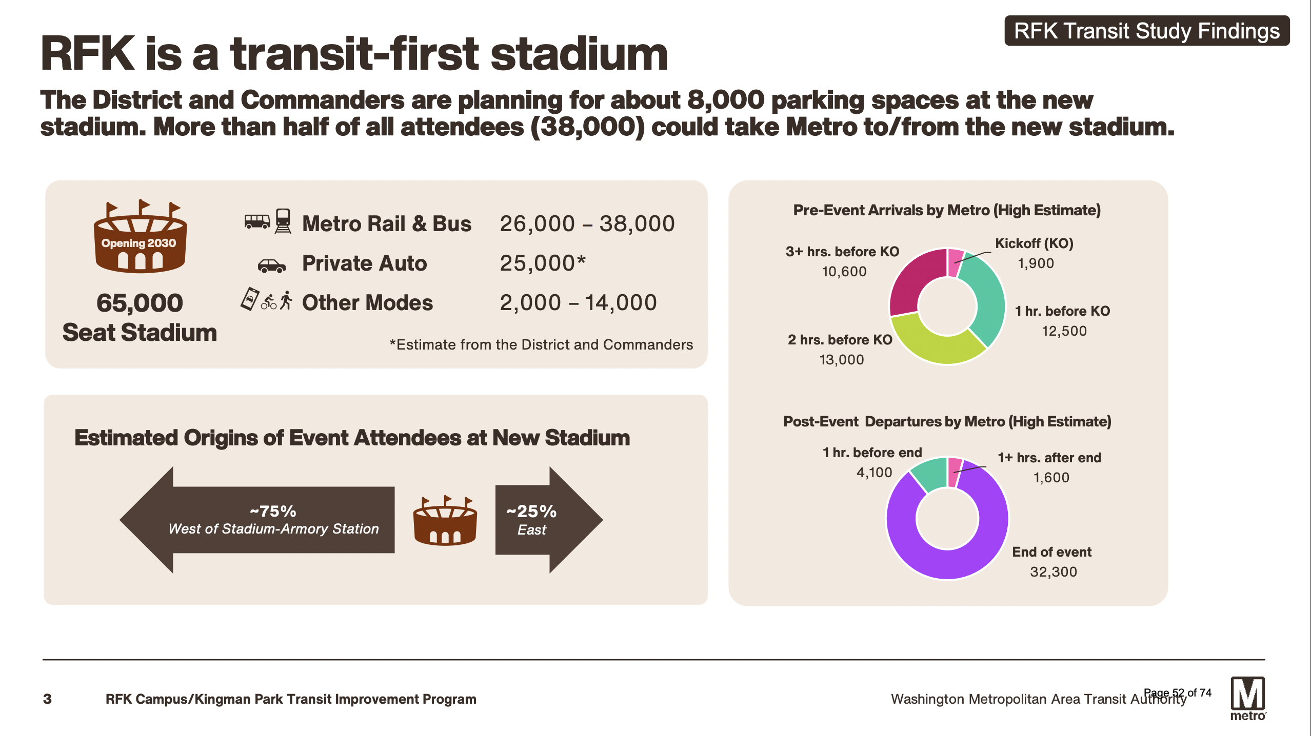
Source: WMATA RFK Campus / Kingman Park Transit Study Findings
The District and Commanders are planning for a transit-first redevelopment, with WMATA estimating that 26,000 to 38,000 attendees could use Metrorail and Metrobus to travel to and from events. The greatest operational challenge will occur after events, when nearly 32,000 passengers could enter the transit system within a single hour, roughly two to three times the post-game ridership recorded after the three highest-attended Nationals games at Navy Yard-Ballpark. Approximately 75% of those riders are expected to travel west toward downtown, transferring to other Metrorail lines and regional services, concentrating passenger volumes at stations such as Metro Center and L’Enfant Plaza.
The site’s existing transit network provides a strong foundation, but it was not designed to accommodate this level of demand. Stadium-Armory is served by the Blue, Orange, and Silver Lines, while the H Street and Benning Road corridors provide frequent, all-day Metrobus service. However, the station’s entrances, mezzanine, elevators, and escalators can currently accommodate only about 14,000 passengers per hour, less than half the projected post-event demand. Without improvements, WMATA estimates it could take more than two hours to clear attendees from the station, creating safety concerns, delaying riders, and causing disruptions throughout the broader transit network.
Roads and Parking
The new stadium will generate significant event-day traffic, even under a transit-first approach. Current plans include approximately 8,000 parking spaces for the roughly 65,000-seat stadium, accommodating an estimated 25,000 attendees arriving by car. While this is substantially fewer than the approximately 22,000 spaces at the Commanders’ current stadium, thousands of vehicles will still converge on the campus during relatively short arrival and departure windows. Managing this demand without overwhelming surrounding streets or disrupting Hill East and Kingman Park will be a central transportation challenge.
At opening, roughly 75% of the proposed parking would be in garages and 25% in surface lots. Concentrating parking in structures preserves more of the campus for development and public space. The campus’s new street network must do more than move vehicles: it must safely distribute event traffic while supporting buses, bicyclists, pedestrians and the daily needs of a growing mixed-use neighborhood.
Bike and Pedestrian
Although current forecasts do not specify how many attendees will walk or bike to or from the stadium, WMATA estimates that between 2,000 and 14,000 could arrive by modes other than private vehicles or transit. Accommodating and incentivizing this demand will require safe connections between the stadium, Stadium-Armory station, and nearby neighborhoods. Expanded sidewalks, protected bike lanes, secure bike parking, bikeshare capacity and upgraded pedestrian tunnels beneath C Street and Independence Avenue will help ensure walking and biking remains practical for event crowds and residents year-round.
Proposed Transit Improvements
WMATA has identified three complementary priorities for meeting the anticipated increase in transit demand at the new RFK site: expanding Stadium-Armory Station, developing the Gold Line Bus Rapid Transit (BRT) connection, and implementing event-day operational strategies. Advancing all three will be essential to make transit a safe, reliable, and convenient option by the stadium’s planned 2030 opening.
Stadium-Armory Station Enhancements
WMATA’s preliminary plans to expand the capacity of Stadium-Armory station would add elevators, escalators, stairs and faregates; expand internal mezzanine and passageway space; and significantly enlarge the station’s north entrance closest to the RFK campus. Together, these improvements are intended to double the station’s circulation capacity from approximately 320 to 640 people per minute, allowing trains to operate about every three minutes and reducing the time needed to clear post-event crowds to roughly 60–75 minutes. The upgrades would also improve accessibility and distribute passengers more evenly across the platform, creating safer and more efficient trips for event attendees and everyday riders alike.
While redevelopment plans have not identified a new use for the site, the D.C. National Guard’s planned relocation from the D.C. Armory presents an opportunity to incorporate the parcel into improvements to the Stadium-Armory station.
WMATA also evaluated constructing a new Metrorail station or platform closer to the stadium but determined that the option would be too costly, complex, and time-consuming. A new station would cost more than $1 billion, require disruptive construction along a curved and elevated section of track, and could not be completed before the stadium’s planned 2030 opening. It would also serve the same Blue, Orange and Silver Line tracks and largely the same riders as Stadium-Armory, offering limited additional service benefits. Therefore, WMATA recommends concentrating resources on expanding the existing station and supplementing Metrorail capacity with the proposed Gold Line BRT service.
Gold Line BRT
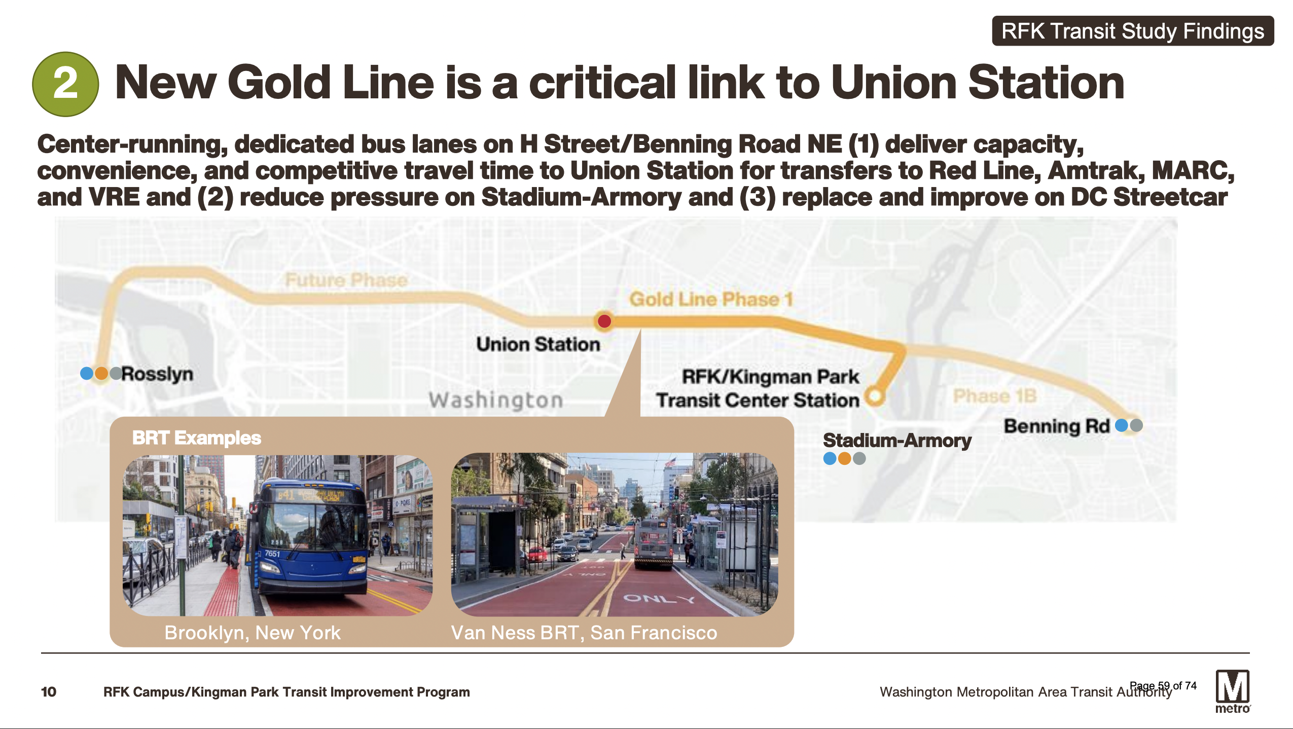
The most significant addition to the proposed transit network is a new bus rapid transit (BRT) route, branded as the Gold Line. WMATA’s initial concept would connect a new RFK Transit Center Station with Union Station through center-running bus lanes along Benning Road and H Street NE. The route would provide a direct, 10-minute rapid transit connection between the RFK campus and the Red Line, Amtrak, MARC and VRE, expanding regional access and giving riders another high-capacity option for reaching the RFK campus without traveling through Stadium-Armory. This connection would be particularly important after events, when approximately 75% of Metrorail riders are expected to travel west toward downtown and transfer to other parts of the region. The Gold Line is intended to operate as a true industry-standard BRT, not a conventional bus route with new branding. WMATA’s concept calls for red-painted, center-running lanes that are physically separated from general traffic where feasible, limiting conflicts with turning vehicles, parking, deliveries and other curbside activity. Other proposed features include transit signal priority, restrictions on turns across the busway, level and all-door boarding, distinct stations and frequent service as often as every three minutes during periods of high demand. These elements will be essential to providing a reliable trip even when surrounding streets are congested on event days. Although the first phase would connect RFK and Union Station, WMATA has identified opportunities for the Gold Line to become a broader regional transit corridor. Future phases could extend east to the Benning Road Metrorail station and west through downtown toward Rosslyn. Notably, the proposed Gold Line western expansion route would provide rapid transit access to Georgetown, an area currently not serviced by Metro. Even its initial segment would replace and improve upon the existing H Street–Benning Road streetcar corridor, creating faster and more reliable service while connecting several major transit networks. The Gold Line should therefore be planned not only as an event-day shuttle, but as a lasting investment serving neighborhoods, businesses and destinations along the corridor every day. Operational strategies In addition to station improvements and the construction of a new BRT line, WMATA has proposed a number of operational strategies that will help manage post-event crowds safely and efficiently. Strategies include metering customers into the station in timed waves to prevent overcrowding; increasing Metro staffing on event days to guide customers and manage flow; and encourage customers to board the first available trains to maximize train capacity. At the proposed transit center, operations would prioritize rapid bus boarding and departures. Together, these global best practices would help pace passenger flows, keep trains and buses moving, and promote safe and efficient travel throughout the system. Project timeline WMATA and the District are working toward completing the transit improvements before the stadium’s anticipated summer 2030 opening. WMATA and the District must still select a lead agency, finalize the route and station locations, identify funding, conduct environmental review and advance the project through design and construction. Implementation will also require DDOT to reallocate street space, modify signals and intersections, potentially relocate utilities and establish effective lane enforcement. These decisions will need sustained coordination among WMATA, DDOT, the RFK Campus Program Management Office, the Commanders, Union Station partners, residents and businesses along H Street and Benning Road. WMATA’s preliminary schedule calls for reaching 30% design and beginning design-build procurement by winter 2027, followed by final design, permitting, and engineering through 2028. Construction would then occur from approximately summer 2028 through spring 2030. Meeting this timeline will require sustained coordination, timely funding, and expedited project delivery to ensure the transportation network is ready on day one. |